Water Quality Monitoring on the Severn
by Elvia Thompson
 (October 19, 2020) – The Severn River Association has been monitoring water quality in the creeks and main stem of our capital river for several years. This year it’s been doing this since early spring – even with the pandemic. Yesterday I joined in so see how it’s done. SRA executive director Tom Guay directed the operation as captain although the two young women who made up the crew needed no guidance as they had the routine well in hand.


Our masked crew consisted of Emi McGeady (left), who, as SRA Field Investigator, is working at SRA as a Chesapeake Conservation Corps participant after graduating from the University of North Carolina at Chapel Hill. Also joining us was Summer Intern Amelia Johnson (right), a senior at St. Mary’s High School who plans to major in Environmental Studies when she starts college next year.
The job yesterday was to take readings in some of the Severn’s creeks north of Annapolis to include Mill, Burley, Rideout and Whitehall.
 Apart from enjoying the spectacular day and unique views of some of the area’s most beautiful homes and boats, I joined in the work.

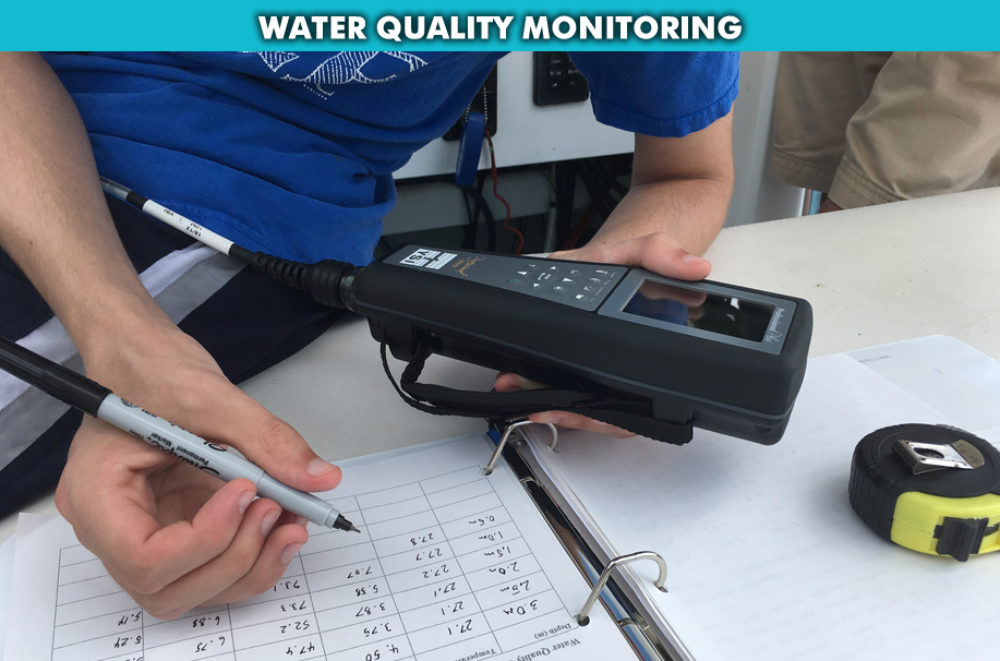
We took several readings in various locations in each creek. My job was to hold the sensor at various depths in the water column at each monitoring location. Amelia read data aloud from the sensor and Emi recorded salinity, dissolved oxygen, pH, temperature, and acidity (pH). Tom put the Secchi disk in the water to measure clarity which Emi also recorded. We did this 33 times.
At the end of the season the data will be added to the Chesapeake Monitoring Cooperative’s citizen science dataset via the Chesapeake Data Explorer program. The Cooperative shares water quality data for the entire Bay watershed and tracks tidal and non-tidal data with a grant from the Chesapeake Bay Program (the federal, multi-state, multi-jurisdictional organization led by the EPA). This river and creek data is an important piece of the puzzle of what makes up the Chesapeake Bay. Scientists take all the data obtained by volunteers and scientists throughout the year to determine if restoration efforts are working and what needs to be adjusted.

For its part, SRA uses collected data all year to provide weekly updates on status of the River, tracking dead zones all summer, pernicious algae blooms, sediment plumes, other activities on the river. That makes the monitoring program important for connecting residents to the River too.
SRA used the data collected to produce and release the Annual State of the Severn on April 23 and a River report card with grades for dissolved oxygen, clarity, swimming safety and abundance of underwater grasses properly known as subaquatic vegetation (SAV). When people living in the River’s watershed understand what is happening in the River they will be more likely to work to improve conditions and protect the River.

The organization visits its 44 monitoring stations in the 17 creeks and mainstem that make up the Severn River. Measuring the creeks is key to understanding the true makeup of the 14-mile-long river whose many miles of shoreline range from the natural flora and fauna that would have been familiar to the indigenous people and Captain John Smith to beautiful estates with piers and boathouses to the urban landscape of busy Annapolis. I had forgotten just how much shoreline the Severn and its tributaries contain.
SRA relies on a team of 25 volunteers and three boat captains to do the monitoring week every week, all season, from May through the end of fall, four days a week. It’s a major effort and it’s possible thanks to a grant from Delaplaine Foundation.
As is the case with most of the rivers in the mid and northern part of the Bay, the Severn is an impaired river, an EPA designation based primarily measurements of nitrogen, phosphorous and sediment. This summer the SRA found dead zones in several parts of the River – areas where there is so little dissolved oxygen that fish and crabs go elsewhere. If the level is low enough and they can’t get away they suffocate and die.

Dead zones caused by algae blooms because when the algae die and bacteria get to work decomposing it, they use up the oxygen in the water. This is most common in hot weather. This year there were times when dead zones were up to five meters tall from the bottom. Fish move closer to the surface where there is more oxygen if they can. Algae blooms also make it hard for underwater grasses to grow because it blocks sunlight from reaching the bottom. These grasses are important for development of young marine life.
This summer dead zone conditions were found from June through Labor Day from the Route 50 bridge through Round Bay and up to headwaters. Dead zones were also found at one time or another in most of the River’s creeks, especially Weems, Luce, Saltworks, Clements, Chase, and Brewer.
And it’s all our fault.
Stormwater runoff, carrying sediment, fertilizers, pesticides and other toxic materials makes it difficult, if not impossible for underwater grasses, fish, and shellfish like crabs and oysters to thrive or to even survive. And with the effects of human-induced Climate Change upon us, our waters will get hotter and more acidic, likely altering the type of critters that live in the waters and along the shore. That’s why monitoring is so important – so scientists can better understand what’s happening and advise policy makers on next steps. Emi and Amelia are learning firsthand how human activity alters Nature.
SRA was founded in 1911 and is the oldest river organization in the country. Its website, severnriver.org, contains a lot of info about the river and the organization’s many programs and volunteer opportunities. Its staff and volunteers monitor the entire river and its creeks from its stations ranging from Lake Ogleton to Indian Landing. It works closely with the Spa Creek Conservancy too.
 One of the things that made the day especially enjoyable for me was Tom’s narrative of the history of the area (he’s a history buff, author of a historical novel, and former heritage guide in Annapolis) and of its natural history. He is a treasure trove of stories and scientific data.
At the end of our monitoring work we explored Meredith Creek, which begins under Route 50. Tom set some waypoints that may be the sites of new monitoring stations next year.
Yesterday we didn’t monitor oysters or SAV but SRA reports that oysters in the Severn are doing well. No dead zones were found south of the Route 50 bridge this summer.
On the chilly quick return trip to the slip in Back Creek, the wide expanse of the Bay – bookended by the Bay Bridge on one end and Thomas Point Shoal Lighthouse on the other – filled my heart and reminded me how lucky we are to live here and how important it is to protect this unique estuary.

The SRA crew will continue its work until it gets too cold to attract volunteers to help – probably in December. For now the SRA boat will get under weigh from Port Annapolis in Back Creek four days a week to gather data – up close and personal with the Severn. Reliable volunteers are welcome. Read more about the program.
It’s messing about in boats for a good purpose. There’s nothing better than that!